| Statistics Toolbox | |
Reconstructing a Map from Inter-City Distances
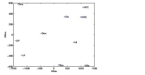
Given only the distances between 10 US cities, cmdscale can construct a map of those cities. First, create the distance matrix and pass it to cmdscale. In this example, D is a full distance matrix: it is square, symmetric, has positive entries, and zeros on the diagonal.
cities =
{'Atl','Chi','Den','Hou','LA','Mia','NYC','SF','Sea','WDC'};
D = [    0  587 1212  701 1936  604  748 2139 2182   543;
       587    0  920  940 1745 1188  713 1858 1737   597;
      1212  920    0  879  831 1726 1631  949 1021  1494;
       701  940  879    0 1374  968 1420 1645 1891  1220;
      1936 1745  831 1374    0 2339 2451  347  959  2300;
       604 1188 1726  968 2339    0 1092 2594 2734   923;
       748  713 1631 1420 2451 1092    0 2571 2408   205;
      2139 1858  949 1645  347 2594 2571    0  678  2442;
      2182 1737 1021 1891  959 2734 2408  678    0  2329;
       543  597 1494 1220 2300  923  205 2442 2329     0];
[Y,eigvals] = cmdscale(D);
Next, look at the eigenvalues returned by cmdscale. Some of these are negative, indicating that the original distances are not Euclidean. This is because of the curvature of the earth.
format short g
[eigvals eigvals/max(abs(eigvals))]
ans =
  9.5821e+006            1
  1.6868e+006      0.17604
       8157.3    0.0008513
       1432.9   0.00014954
       508.67  5.3085e-005
       25.143   2.624e-006
  5.3394e-010  5.5722e-017
       -897.7 -9.3685e-005
      -5467.6   -0.0005706
       -35479   -0.0037026
However, in this case, the two largest positive eigenvalues are much larger in magnitude than the remaining eigenvalues. So, despite the negative eigenvalues, the first two coordinates of Y are sufficient for a reasonable reproduction of D.
Dtriu = D(find(tril(ones(10),-1)))';
maxrelerr = max(abs(Dtriu - pdist(Y(:,1:2)))) ./ max(Dtriu)
maxrelerr =
    0.0075371
Here is a plot of the reconstructed city locations as a map. The orientation of the reconstruction is arbitrary: in this case, it happens to be close to, although not exactly, the correct orientation.
| | Overview | Statistical Plots | |